Finally part three! After our cave tour we decided that we should go for a hike to check out some of the more popular places near the visitor center.

We descended down the paved trail that led us to the historic entrance, and then continued down this gravel path. It was a very steep trail, so that having a stroller made me more than a little nervous. The topography of the area is quite interesting, since the Green River lies deep down in the valley and the underground rivers and streams which make the cave flow right into it, without any waterfalls or rapids. So we headed down to one of the biggest cave-tributaries, the River Styx.

It was drier than I expected; had it been a little deeper and a little less…disgusting, I might have brought Michael down there to dip him in head-first while holding onto his ankle. Then, learning from Thetis’ mistake, I would have sunk the ankle as well. You can never be too careful. It’s too bad (or “a really good thing,” depending on how sane/lame you are) that Cait responds to these epic (!) ideas of mine with a simple, “You’re ridiculous.”


My Little Achilles
After having descended as much as we did, we weren’t in the mood for a steep return ascent. So instead of going straight back, we took the long way around:

It doesn’t help that National Parks Service maps don’t typically include contour lines, so I had to guess based on other features that the map did include (like streams and creeks) to avoid steep hills as much as possible. After an initial ascent, we got some great views of the River Styx from about 100-150 feet above it:


After walking alongside the hill/mountain/cliff, we continued on into some forest with rolling hills. We came across an old cabin along with a deer. We have about a dozen deer that live near our house (read: in our backyard)…you’d think that seeing a deer in a National Park wouldn’t be a big deal. You’d be wrong.


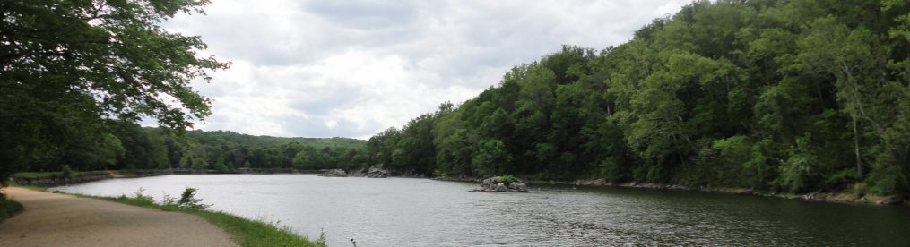
We next hiked over to the mouth of the other significant cave-tributary, the Echo River, which emerges from underground as a kind of spring, rather than out of a cave like the Styx. Somewhat underwhelming:

Now we prepared ourselves for the ascent back. It was rocky, which was both interesting and challenging, on account of the stroller. This was a more manageable section; they’re obviously trying to prevent trail erosion.

We thought we were making it close to the top when we came upon an entrance to the cave which has been closed to us lay folk. I gather that with the proper training, documentation and permits you can gain access to more remote sections of the cave along with these more challenging entrances.


We thought we were done climbing, and then we began to descend again. It’s simple but important: on loop trails/hikes you begin and end at the same spot, and so at the same elevation. So any descent you have to “pay for” with an equal and opposite ascent. So we were not in the mood to be going downhill at this part of the hike! We were, however, able to get a shot of a significant sinkhole, the Mammoth Dome Sink. I promise there’s a cave under there.

Fifteen minutes later we were back to civilization. Given how many people were at the visitor center I was shocked at how few people there were on these trails that were right nearby. The park has 80+ miles of trail and we only covered about four, on trails in the visitor center detail portion of the park map. We were hardly in the backcountry, but only came across a dozen or so people on a summer weekend in an otherwise crowded park. I guess people don’t want to stray too far from the bathrooms and fried food. If you’re looking for a calmer park experience, walk for five minutes into the woods!

See that 1 inch pink square? Here’s the close up, and we hiked only about half of the trails included here. For the record: Visitor’s Center to Historic Entrance, down River Styx Spring Trail, down the Echo River Spring Trail, then up the Mammoth Dome Sink Trail, past White’s Cave and the sinkhole, then along the Heritage Sidewalk (ahem) back to the Visitor Center.

Great hike and great park. As you can see from the big map, Mammoth Cave lies just a few miles west of I-65. If you’re ever driving by, you should stop in for a visit!

Pingback: Mammoth Cave | Photomiser